Reservoirs
Reservoirs are man-made lakes constructed by damming up a stream. The flooded canyon or valley provides a widely varied habitat. Engineers design reservoirs to store the greatest amount of water for irrigation, flood control, or electricity production. Hence reservoirs are sited with depths in mind and are usually very deep in character. The dam’s height approximates its maximum depth. The significance to the angler is that most of the water of a reservoir lies outside the productive shallow littoral zones. An optimistic angler may view such a reservoir as a place where all of that immense water concentrates its fish in its limited shallows.
New reservoirs are much more productive than old ones. The recent flooding of standing vegetation causes its organic decay to be released into the food chain. This enhanced situation provides a temporary boomtown for aquatic weeds, insects, and fish. After a few years this organic matter is used up and the reservoir loses much of its food chain causing the fishery’s decline. Hence, new reservoirs are hot spots which inevitably fade.
A reservoir’s terrain conveys much to the structure of its fishery. Flooding vast expanses of shallows can create giant littoral zones. A disadvantage is that these
littoral zones are subject to reservoir draw downs which fluctuate its depths and may cause much of it to go dry during the late summer season. This seasonal fluctuation deteriorates the quality of its littoral zone and of its fishery.
Flood control reservoirs can be subject to much silt being deposited during the runoff times. This can be detrimental to the fishery of such reservoirs. An example is Montana’s Ennis Lake which has silted up so severely that it now overheats the water released into the once great Bear Trap Canyon of the Madison River. Now August water temperatures can soar to an excess of 70° F, causing fish kills. This reservoir was initially a great trout producer but has deteriorated into a very limited fishery which has also affected its outlet river.
Utah’s enhanced Strawberry/Soldier Creek Reservoir offers a more stable fishery. Here many small streams that are relatively free of silt were damned to form one huge reservoir. Its terrain consists of shallow valleys which when flooded, became immense littoral zones. Its elevation and temperatures are also ideal for trout habitat. Biologists manage this reservoir by stocking and maintaining it as a prime fishery. Strawberry Reservoir is an example of one of the better reservoirs.
The huge Colorado and Green River impoundments had their heydays when they were young. Flaming Gorge Reservoir was a trophy brown and rainbow trout fishery in its early days; now it is primarily a lake trout and smallmouth bass fishery. Lake Powell has changed from a fantastic largemouth bass and crappie fishery to a striped bass one. There are still fish to be caught in these older reservoirs, but it takes some knowledge of where and how to fish them. In their youth, little skill was needed to catch fish.
The key to reservoir fishing is to search out the productive areas such as: inlets, channels, drop-offs, weed beds, shallows, shoals, cliffs, and land points. Using accurate topographic maps of the terrain prior to flooding facilitates the location of these structures. The huge sizes of these reservoirs can easily conceal productive areas. A boat with a quality video sonar and time spent prospecting are assets to productive reservoir fishing.
Large portions of a reservoir harbor few or no fish. All of the fish are found concentrated into the few prime areas. Find these places and spend your time productively fishing them and not wasting your time in the fish-poor areas.
Reservoirs stratify into the epilimnion, thermocline, and hypolimnion areas during the warm months of the year. (See Diagram 1) Since reservoirs tend to be deep, the hypolimnion area can be vast. The epilimnion is where light penetrates causing submerged weed growth. That is the productive portion of a reservoir. It also generates the dissolved oxygen needed to sustain life. The thermocline is the transitional zone with a drastic drop in water temperature which separates the epilimnion and hypolimnion layers. The oxygen and food supply is limited to the epilimnion and somewhat to the thermocline layers. The hypolimnion is usually depleted of food and oxygen making it unproductive. Learn to detect areas where the epilimnion and the thermocline correspond to the lake’s bottom. Spend your time fishing these waters and eliminate the hypolimnion area
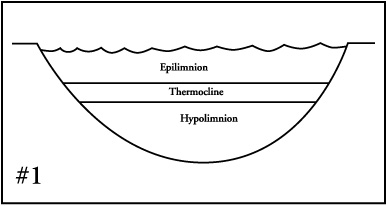
altogether. A thermistor with an oxygen monitor is useful in locating these layers. Next use your video sonar to find structured areas which fall into the desired epilimnion and thermocline areas.
During very warm weather the epilimnion may become too warm to hold adequate oxygen for fish to sustain themselves. Fish will seek the thermocline where cooler waters can hold more oxygen. Remember at this time the hypolimnion is cold but still oxygen poor. The lake’s entire fish population can be concentrated into the limited area of the thermocline. Locate bottom structure at the same depth as the thermocline and the fishing can be amazing.
Lake zones are also classified as being littoral, pelagic, and profundal zones; (See Diagram 2) this classification is based on
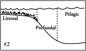
light penetration and plant growth. The littoral zone is where photosynthesis occurs and concentrates the lake’s food chain. The profundal zone is the deepest portion of a lake where photosynthesis and plant growth is severely limited; it is where little light penetrates. This profundal zone supports few fish and deep reservoirs harbor vast acreage of this zone. The pelagic zone is the top portion of the profundal zone and this pelagic zone is bordered on its sides by the littoral zones. Penetrating sunlight reaches here and oxygen is high but its bottom is only accessed by going through the dead profundal zone. Its importance is that where the pelagic zone borders with the littoral zone fish can gather. Hiding in this zone, fish venture out into the shallows to ambush prey.
Junctional habitat seems to consistently concentrate animals; big game species such as elk and deer prefer areas adjacent to both open and forested areas. Elk feed in the open park grasses during low light conditions and migrate to hide in the forest cover during the day. Fish likewise use the pelagic zone as a darkened hideaway safe from predators and concealed from their prey. Surprise attacks on schooled minnows are initiated from this pelagic zone. A reservoir’s largest fish commonly behave in this manner by ambushing their prey at this littoral/pelagic zone junction.
These three zones of littoral, profundal, and pelagic do not change. It is the epilimnion, thermocline, and hypolimnion layers that are subject to changes due to weather conditions such as temperature changes and wind/wave actions.
When selecting a reservoir to fish, take into account its anatomical features. Choose one with the most fish-producing habitat. Look for one with an abundant littoral zone which has lots of weed beds, shoals, drop-offs, islands, peninsulas, inlets, cliffs, rocky and gravel areas within this zone. Fish these structures adjacent to the pelagic zone which provides both deeper, cooler waters and darkened cover to conceal fish.
When fishing reservoirs with limited littoral zones look for areas with structures located within these zones. The few good areas these reservoirs possess may have been under-fished, so these structured areas may provide a seldom-fished hot spot.
Idaho’s failed Teton Dam Reservoir is rarely fished because it was a disaster site. Now its limited backed-up pool contains some of the best trophy cutthroat fishing anywhere. This pool is all prime trout habitat. Every time I’ve ventured there, I’m alone with its abundant trout and rattlesnakes; it has given up cutthroat weighing as much as nine pounds.
In summary, it is difficult to locate prime fish habitat in reservoirs because the vast amounts of stored water conceal them. Discover a reservoir’s features and its fish may be concentrated there. Perhaps you can discover the 10% of a reservoir that holds all of its fish. Identify these places and spend your fishing time angling there.
© 2026 The Gale Group, Inc. All rights reserved.
© 2026 Perigee Learning LLC. All rights reserved.
LoveTheOutdoors.com is owned and operated by Advameg, Inc. © 2026 Advameg, Inc.
Camping Adventures • Dutch Oven Cooking • Sports Knots
Fly Tying • Freshwater Fishing • Fly Fishing